Dangerous winter storm to target Northeast later this week
NEW YORK -- A winter storm will likely bring heavy snow to New England as well as dangerous, icy winds to other northeastern states later this week. Temperatures will warm slightly Wednesday and Thursday ahead of a massive Atlantic storm system.
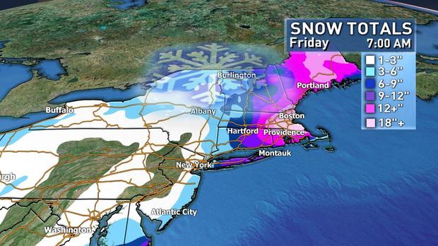
Blizzard conditions are likely Thursday afternoon in Massachusetts, New Hampshire and Maine, and blizzard conditions are also possible in Boston, Rhode Island, Connecticut and Long Island, New York. Wind gusts above 50 mph are likely for much of New England. Snowfall totals by Friday could range from 3-6 inches for New York City to 9-12 inches on eastern Long Island to 12-18 inches or more in coastal New England.
The storm is starting to get organized around Florida thanks to the arctic cold front with the average temperatue for the continental U.S. was 9.1 degrees early Tuesday.
The National Weather Service said as much as a quarter of an inch of ice and a couple inches of snow are possible from portions of the Florida Panhandle to eastern North Carolina Tuesday night and into Wednesday. As the storm moves up along the coast, temperatures will be cold enough that snow could fall in South Carolina, as close to the coast as Myrtle Beach.
On Thursday morning, the storm will start to intensify in the Northeast. The heaviest snow should be in Delaware, Maryland, Virginia and the Jersey Shore. Snow is expected to start in New York City around morning commute time Thursday.
Snow should arrive in New England by noon and then intensify into blizzard conditions in the afternoon and evening hours. Snow is forecast to wrap up Thursday morning in the New York metro area and by Friday morning in Maine. Snow should end in the early morning hours of Friday in the Boston metro area.
This storm system will see strong winds out at sea and a similar central pressure to a hurricane. It is an extremely powerful storm with a very strong wind component that will create white-out and blizzard conditions.
Blizzards are not a function of how heavy the snow is, but rather how strong the wind is and how poor the visibility. While it's not expected to be a "top 10" storm in terms of snowfall totals, it could still be crippling because of the high winds.
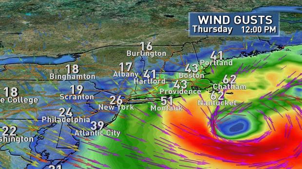
The biggest threat from this storm is from power outages. Winds up to 40 and 50 mph could cause power problems, and the extreme cold that follows presents a very dangerous situation for people without electricity.
The high in Boston on Saturday morning likely stays around zero and New York City will stay in single digits. Sunday morning will be the coldest in the forecast, with a low of 15 below zero in Boston and 2 below zero in New York City.
Next week, the temperature may finally rise above freezing in the Northeast, but until then, the freezing line goes all the way down to the Carolinas and Florida. The majority of the U.S. will remain in the deep cold for the foreseeable future.
As for the western states, the National Weather Service said rain will move to California and the Pacific Northwest by Wednesday evening; above-normal temperatures are expected to continue across the West Coast.