Weakened Hurricane Irma takes aim at Tampa -- live updates
A new article has been published with the latest updates on Hurricane Irma.
A massive but weakened Hurricane Irma zeroed in on the Tampa Bay region early Monday after hammering much of Florida with roof-ripping winds, gushing floodwaters and widespread power outages.
Irma continued its slog north along Florida's western coast having blazed a path of unknown destruction. With communication cut to some of the Florida Keys, where Irma made landfall Sunday, and rough conditions persisting across the peninsula, many held their breath for what daylight might reveal.
Irma roared through the Florida Keys on Sunday with punishing winds before pushing its way north, flooding streets, spawning tornadoes, knocking out power to more than 3 million people across the state and snapping massive construction cranes over the Miami skyline.
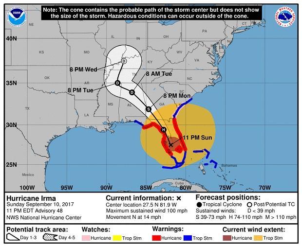
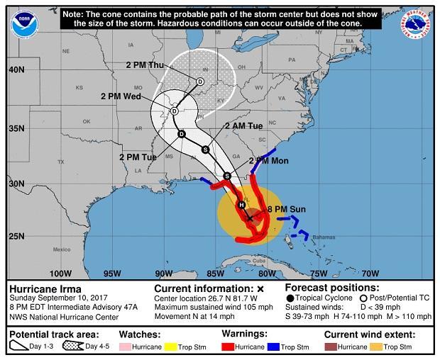
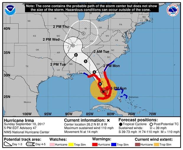
The National Hurricane Center (NHC) said in its 2 a.m. advisory that Irma was about 25 miles northeast of the Tampa-St. Petersburg region would continue moving north over the western Florida peninsula through Monday morning and then into the southeastern United States late Monday and Tuesday.
- Florida man's joke about shooting Irma gets more than 50,000 responses
- Video shows couple rescued from boat trying to ride out Hurricane Irma
- Miami Beach mayor in his office as Hurricane Irma lashes Florida
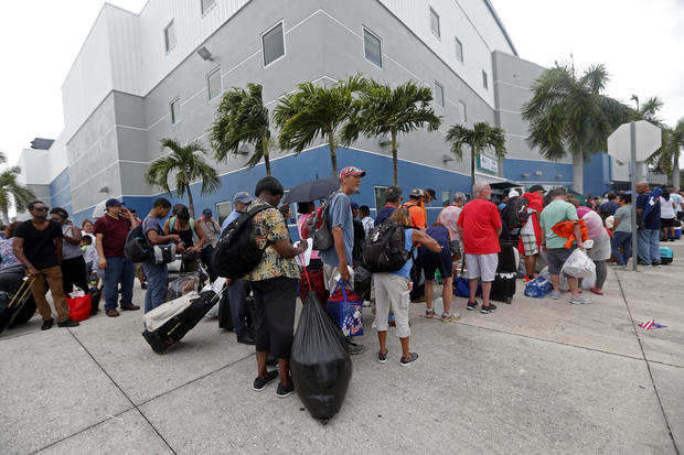
Streets had emptied across the bottom half of the Florida peninsula, and some 127,000 people were huddled in shelters.
Late Sunday afternoon, Irma made landfall on Marco Island as a Category 3 storm. The NHC in Miami said Irma's powerful eye roared ashore at Marco Island just south of Naples with 115 mph winds, for a second U.S. landfall at 3:35 p.m. Sunday. Category 3 storms have winds from 111 to 129 mph, but a 130-mph wind gust was recently reported by the Marco Island Police Department.
There were no confirmed deaths blamed on the storm in the U.S. as of late Sunday evening. The storm left at least 27 people dead as it tore across the Caribbean.
"I know the winds are going to be very devastating and life threatening. But I'm also very concerned about the storm surge," Gov. Rick Scott said on "Face the Nation."
While the projected track showed Irma raking the state's Gulf Coast, forecasters warned that the entire state -- including the Miami metropolitan area of 6 million people -- was in extreme peril because of the sheer size of the storm.
Nearly 7 million people in the Southeast were warned to evacuate, including 6.4 million in Florida alone.
Follow along below for live updates on the storm. All times are Eastern unless otherwise noted.
2:38 a.m.: Irma downgraded to Category 1 near Tampa
Irma weakened to a Category 1 storm as the massive hurricane zeroed in on the Tampa Bay region early Monday after hammering much of Florida with roof-ripping winds, gushing floodwaters and widespread power outages.
The hurricane's maximum sustained winds weakened to 85 mph with additional weakening expected.
As of 2 a.m. ET, the storm was centered about 25 miles northeast of Tampa and moving north-northwest near 15 mph.
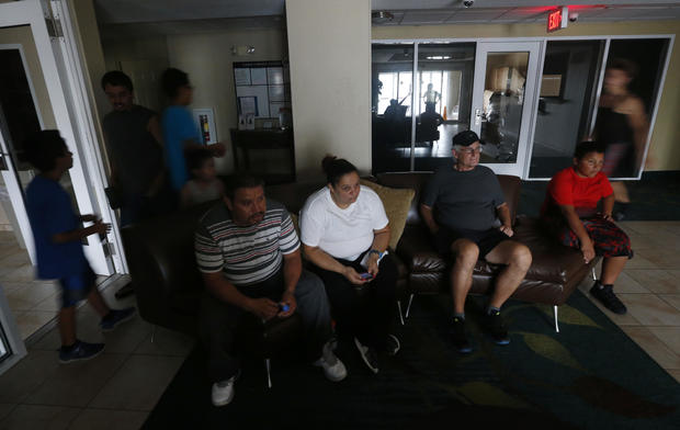
More than 160,000 people waited in shelters statewide early on Monday morning.
Sunday, Sept. 10
11 p.m.: Hurricane Irma nears Tampa as Category 2 storm
Hurricane Irma remains a dangerous Category 2 hurricane despite weakening a bit more to 100 mph. It's now bearing down on the Tampa-St. Petersburg region.
NHC released its latest advisory to report that Irma's eye is about 50 miles southeast of Tampa and moving at a fast clip of 14 mph. Still a large hurricane, its tropical storm force winds extend out 415 miles.
Forecasters say they expert Irma's center to stay inland over Florida and then move into Georgia, Alabama and Tennessee.
They also expect Irma to weaken further into a tropical storm over far northern Florida or southern Georgia on Monday as it speeds up its forward motion. The hurricane center says the storm is still life-threatening with dangerous storm surge, wind and heavy rains.
10:52 p.m.: University of Tampa students hunker down in dorms
CBS News correspondent Don Champion spoke with students from the University of Tampa who decided to stay in their dormitories throughout Hurricane Irma because the facilities were rated for Category 5 storms and they felt very safe.
Gusts have been reported up to 50 mph and officials are expecting a storm surge for up to 6 feet. This is a city that is very flood prone so city officials are warning folks that the threat from Irma is far from over, Champion reports.
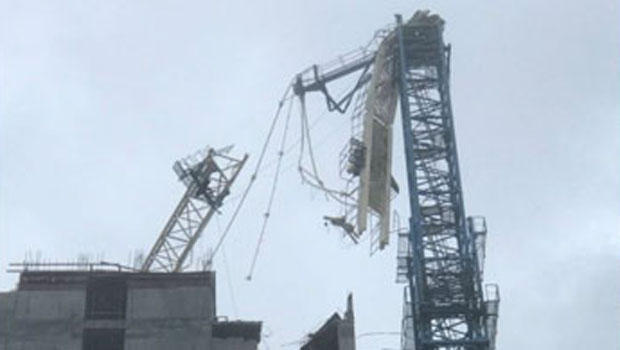
10:25 p.m.: 3rd construction crane falls to Irma's winds
A third construction crane has toppled in Florida in the powerful winds of Hurricane Irma.
Officials say it happened at a project on Fort Lauderdale beach during the storm Sunday.
Officials with developer The Related Group told the Sun-Sentinel the crane collapse caused no injuries and did not appear to damage anything else.
Two other cranes toppled earlier in Miami as Irma swirled up the state.
9:18 p.m.: Miami International Airport sustains "significant water damage"
Miami International Airport will be closed Monday after sustaining "significant water damage" on Sunday from Hurricane Irma's powerful gusts of nearly 100 mph, Miami-Dade Aviation Director Emilio González announced on Twitter.
The airport expects to begin operations with limited schedules Tuesday.
8:57 p.m.: 3.3M Floridians without power
More than 3.3 million homes and businesses have lost power in Florida as Hurricane Irma moves up the peninsula. The widespread outages stretch from the Florida Keys all the way into central Florida.
Florida Power & Light, the state's largest electric utility, said there were nearly 1 million customers without power in Miami-Dade County alone. The power outages are expected to increase as the storm edges further north.
There are nearly 7 million residential customers in the state.
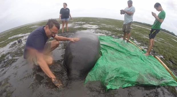
8:26 p.m.: Manatees rescued after low tide in Sarasota Bay
Hurricane Irma pulled water from Sarasota Bay on Sunday afternoon and left several manatees stuck in knee-deep mud.
A few residents in the area came to the rescue, placing them on large green tarp and pulling them more than 100 yards back into the water.
After becoming restless, Marcelo Clavejo checked out the bay near Whitfield where he noticed the manatees on the flats. "So we went for a ride and ended up saving two manatees," Clavejo posted on Facebook.
8:15 p.m.: Irma moves toward Fort Myers
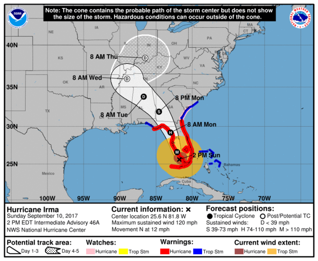
The National Hurricane Center said in its 8 p.m. advisory that Hurricane Irma is moving northward near Fort Myers and that dangerous storm surges are expected in areas of onshore winds along the Florida west coast. Irma was 15 miles east-northeast of Fort Myers and about 30 miles southeast of Port Charlotte.
Maximum sustained winds have decreased to 105 mph, according to NHC and is moving north at about 14 mph.
Irma's eye should move near or over the west coast of the Florida Peninsula through Monday morning, the center says. Irma should the move inland over northern Florida and southwestern Georgia on Monday afternoon.
Irma is expected to remain a hurricane through Monday morning -- and that hurricane-force winds extend outward up to 80 miles from the center -- and tropical-storm-force winds extend outward up to 220 miles.
7:26 p.m.: Roof leaks as thousands shelter in Germain Arena
The Lee County Sheriff's Office says water began leaking through the roof at the Germain Arena shelter in Estero just as the eye of Hurricane Irma drew near.
Thousands of evacuees have crowded into the minor-league hockey stadium, which seats about 8,400 people and is being used as a shelter.
The sheriff's office said on Facebook that authorities are monitoring the problem and that the facility is stable.
7:20 p.m.: Miami-Dade schools to remain closed
Miami-Dade County Public Schools will remain closed until further notice, Superintendent Alberto Carvalho announced late Sunday.
"Due to uncertainty surrounding shelter closings & inability to inspect/make repairs, [Miami-Dade County Public Schools] remain closed [until] further notice," Carvalho said on the Facebook.
Earlier Sunday, Carvalho said further announcements would be made regarding "shelter closures, school site inspections and workforce readiness."
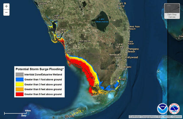
7 p.m.: Storm surge could damage 455,000 Tampa Bay homes
Hurricane Irma should be moving directly over the Tampa Bay area around 12 a.m. on Monday. Residents of the highly populated area are fearing the worst.
A report by CoreLogic, the global property data firm, found nearly 455,000 Tampa Bay homes could be damaged by storm surges, the most of any major U.S. metro area other than Miami and New York. Rebuilding those homes could cost $81 billion.
Tampa Bay is vulnerable because the bay acts as a funnel for storm surges, forcing water into narrow channels with nowhere else to go.
6:36 p.m.: Water levels rise in Naples
Water levels are rising rapidly in Naples, Florida, from Hurricane Irma's storm surge, the National Hurricane Center said Sunday evening. A federal tide gauge in Naples reported a 7 foot rise of water in just 90 minutes.
A wind gust of 142 mph was recorded at the Naples Municipal Airport as the storm kept its top sustained wind speed of 110 mph.
Irma has picked up forward speed and is moving inland at 14 mph and its eye is about 25 miles south southeast of Fort Myers.
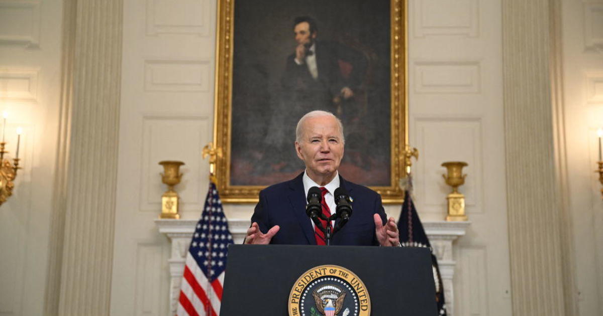
5:30 p.m.: Trump approves disaster declaration for Florida
President Trump approved a major disaster declaration for Florida and ordered federal aid to help the state,
Residents and business owners who sustained losses in the designated counties can begin applying for assistance by registering online at www.DisasterAssistance.gov or by calling 1-800-621-FEMA (3362) or 1-800-462-7585 (TTY) for the hearing and speech impaired.
The federal government will also reimburse counties for emergency protective measures -- including evacuation and sheltering costs and much of the costs for debris removal.
5:15 p.m.: Irma approaches Naples, Florida, as Category 2 storm
The NHC said in its 5 p.m. advisory that Hurricane Irma is about 5 miles north of Naples, Florida, and about 30 miles south-southeast of Ft. Myers, Florida. The storm has maximum sustained winds near 110 mph, the center said.
Irma is moving toward the north near 14 mph and a north-northwestward motion with an increase in forward speed is expected by tonight, with that motion continuing through Monday.
On the forecast track, the eye of Irma should move near or over the west coast of the Florida Peninsula through Monday morning, according to the NHC. Irma should then move inland over northern Florida and southwestern Georgia Monday afternoon.
NHC says Irma is expected to remain a hurricane at least through Monday morning.
3:38 p.m.: More than 2.1M without power in Florida
More than 2.1 million customers have lost power in Florida with Hurricane Irma striking the state. Florida Power & Light reported the numbers Sunday afternoon. The utility, which services much of south Florida, says more than 845,000 of those customers are in Miami-Dade County. Duke Energy, the dominant utility in the northern half of Florida, has about 13,000 outages with the outer bands of Irma sweeping across the region.
3:15 p.m.: Irma disrupts Congress' work schedule
Hurricane Irma is affecting the House of Representative's work schedule in Washington. A notice from the House majority leader's office says the House now doesn't plan to take any votes Monday because of "the large number of absences" as a result of the storm. The first votes of the week are expected Tuesday evening. The House leadership will keep tabs on the situation and announce updates as necessary.
3:10 p.m.: 2nd crane collapses in Miami
Miami City Manager Daniel Alfonso says a second tower crane has collapsed into a building under construction in the city's downtown area. Alfonso told The Associated Press that the crane collapsed in a large development with multiple towers being built by Grand Paraiso.
3 p.m.: Tornadoes reported
The the National Weather Service Miami-South Florida tweeted that a tornado had been reported at Fort Lauderdale International Airport:
Meanwhile, an apparent tornado spun off by Irma destroyed six mobile homes in Palm Bay, hundreds of miles away along the state's Atlantic coast.
1:55 p.m.: Utility says it will take weeks to restore power
Florida Power & Light says it will be weeks, not days, before electricity is fully restored because of the damage being done by Hurricane Irma.
Spokesman Rob Gould said Sunday that an estimated 3.4 million homes and businesses will lose power once the worst of Irma reaches the Florida mainland. He expects thousands of miles of poles and lines will need to be replaced, particularly on the Gulf coast.
1:10 p.m.: Mr. Trump receives briefing on Hurricane Irma
The White House says President Donald Trump has received a "comprehensive update" on Hurricane Irma. Mr. Trump, Vice President Mike Pence and several Cabinet members participated in the briefing from Camp David -- the presidential retreat where Trump has spent the weekend monitoring the storm.
Other administration officials joined in from the White House or Federal Emergency Management Agency headquarters in Washington. Pence and several Cabinet secretaries are planning to visit FEMA headquarters later Sunday.
1 p.m.: Irma's winds impede access to toppled crane site
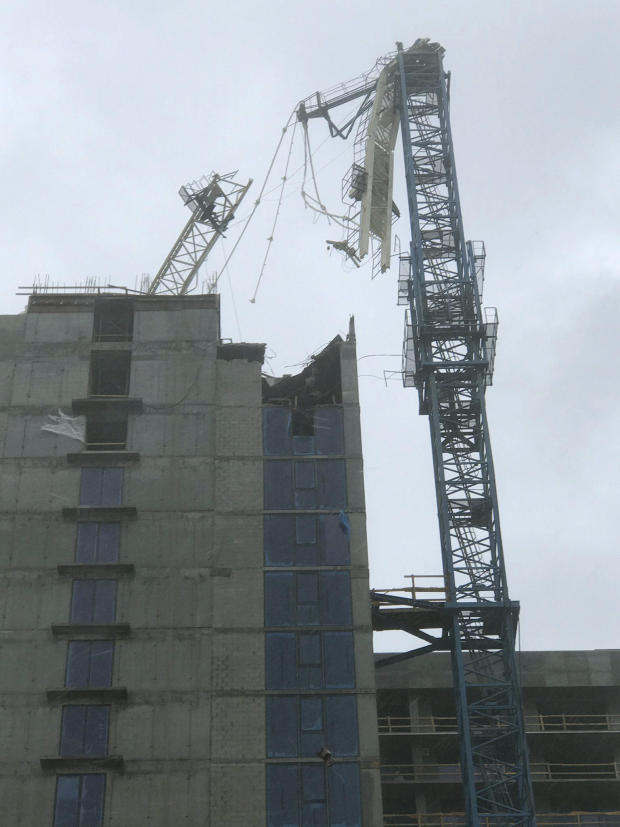
High winds are impeding Miami authorities' ability to reach a construction crane toppled by Hurricane Irma. The crane fell onto a high-rise building that's under construction. It's in a bayfront area filled with hotels and high-rise condo and office buildings, near AmericanAirlines Arena.
Miami-Dade County Director of Communications Mike Hernandez said emergency personnel couldn't immediately respond to the scene because of high winds. Authorities urged people to avoid the area after the Sunday morning collapse. It wasn't clear if there were any injuries.
Miami City Manager Daniel Alfonso said the approximately two-dozen other cranes in the city are still upright and built to withstand significant wind gusts. The tower cranes working on construction sites throughout the city were a concern ahead of Irma. Moving the massive equipment, weighing up to 30,000 pounds, is a slow process that would have taken about two weeks, according to city officials.
12:30 p.m. Florida senator: Irma has potential to be "worst-case scenario"
Sen. Marco Rubio, R-Florida, said Sunday that for those living in Naples, Fort Myers, Sarasota and the Tampa Bay region, Hurricane Irma has the potential to be the "sort of worst-case scenario that meteorologists and emergency planners dread."
There is "virtually no part of Florida that is not going to be impacted by the storm," Rubio said on "Face the Nation."
11:25 a.m.: Mr. Trump speaks with governors in Irma's path
President Donald Trump has spoken with the governors of Alabama, Georgia, South Carolina and Tennessee as Hurricane Irma moves north. All four states could be affected by the storm, which struck the Florida Keys on Sunday.
The White House says Mr. Trump spoke with the officials Sunday from the Camp David presidential retreat, where he was spending the weekend. Mr. Trump has been in regular contract with Florida Gov. Rick Scott and Sen. Marco Rubio over the past week. Chief of staff John Kelly spoke Sunday with Florida Sen. Bill Nelson.
10:20 a.m.: Atlanta gets 1st ever tropical storm warning
For the first time, a tropical storm warning has been issued for the city of Atlanta. The National Weather Service in Peachtree City, Georgia, said Sunday it was the first time such a warning had been issued for the metro Atlanta area. High wind warnings have been issued in previous storms. The warning means that tropical storm conditions are expected within the next 36 hours. Peak winds were expected to reach 30 to 40 mph with gusts of up to 55 mph.
9:45 a.m.: More than 1M lose power
Florida utility officials say more than 1 million customers have lost power as Hurricane Irma hits the state. Florida Power & Light Company said that nearly 1.1 million customers statewide were without power Sunday morning. About 574,000 of those outages were in Miami-Dade County, while there were 360,000 in Broward and nearly 136,000 in Palm Beach County.
9:30 a.m.: Irma makes landfall
Hurricane Irma has made landfall on Cudjoe Key in the lower Florida Keys. The U.S. National Hurricane Center in Miami said the storm's center made landfall at 9:10 a.m. Its top sustained winds are 130 mph.
8:15 a.m.: Hurricane Irma's center poised to blow across Florida Keys, forecasters say
The U.S. National Hurricane Center said in a public advisory that the center of the storm remained offshore but was going to make landfall soon. The storm was centered about 20 miles east of Key West, and it was moving north-northwest at 8 mph.
The storm had maximum sustained winds of 130 mph. The National Weather Service reported wind gusts of 90 mph near its Key West office. After hitting the Florida Keys, Irma was forecast to move up the state's Gulf Coast later Sunday.
8:05 a.m.: Tornado warnings issued
The National Weather Service in Miami has issued tornado warnings for a wide swath of Monroe, Miami-Dade and Broward counties in South Florida.
Officials say the band of rain and tornado producing cells is moving quickly. There have been no reports of tornadoes touching down.
Authorities are urging people to stay inside until the storm passes.
"Due to extreme sustained winds rescue teams are no longer able to respond. Stay inside and Stay safe until the storm has passed," the City of Miami Beach tweeted.
In a Facebook post early Sunday, Key West Police urged people who stayed for the hurricane to remain where they took shelter until the storm had passed completely. They also urged people not to go outside when the eye of the storm is over there area, a time period when conditions can seem deceptively calm.
6:55 a.m.: St. Petersburg now in Irma's crosshairs
With Hurricane Irma churning toward the Florida Key's and the southernmost tip of the mainland on Sunday morning, Florida Power & Light said more than 250,000 homes and businesses were already without power by 6:30 a.m. in Miami-Dade county -- an hour before the storm was even expected to make landfall. Another 97,370 outages were reported in Broward.
The outages were blamed largely on high winds snapping power lines and taking out transformers.
12:40 a.m., Sept. 10: National Hurricane Center tweaks forecast
The National Hurricane Center's latest tweak to Irma's forecasted track has the storm hugging the Florida's west coast off Fort Myers, but possibly not making landfall there before moving back to the Gulf of Mexico. By moving the likely track a few crucial miles west, the storm would be able to regain strength over water before its deadliest winds hit St. Petersburg and Clearwater, rather than the more populated Tampa.
After that, the storm is now expected to skirt the coast again a bit north of Horseshoe Beach, then finally go inland around Fish Creek, northwest of Ocala, with a hurricane-force wind field well over 100 miles wide.
Irma's forward motion slowed to 6 mph as the storm stuttered off the coast of Cuba. Forecasters say it could still increase in strength, but their forecast didn't show it.
11:55 p.m.: South Florida county pulls deputies off roads
The Broward County sheriff's office tweeted late Saturday that with wind gusts measuring 45 mph, they are pulling deputies off the road until conditions are safer.
Fort Lauderdale is located in Broward County.
11 p.m.: Irma is taking its time leaving Cuba
Hurricane Irma is moving slowly away from the north coast of Cuba as hurricane-force winds were recorded in the Florida Keys, the National Hurricane Center said.
A turn toward the north-northwest with an increase in forward speed is expected through late Monday. The center of Irma is expected to pass through the Keys Sunday morning and then move near or along the west coast of Florida Sunday afternoon through Monday morning. Irma should then move inland over the Florida panhandle and southwestern Georgia Monday afternoon.
Dangerous storm surges are expected in Florida, with surges of 10 to 15 feet from Cape Sable to Captiva.
More than 170,000 homes and businesses in Florida are without power, Florida Power and Light said. More than half the outages are in the Miami-Dade area.