NEXT Weather Alert: Winter storm expected to bring heavy rain, snow to area
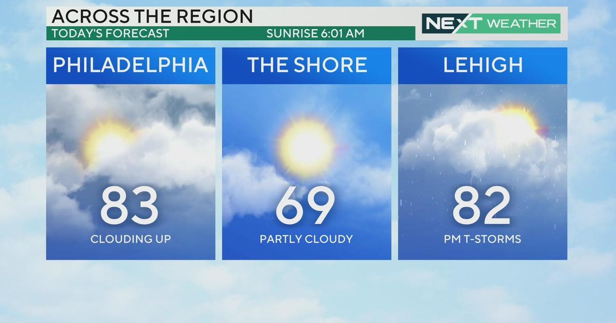
PHILADELPHIA (CBS) -- After a quiet start to the new work week, get ready for a messy mix this evening as a storm system works its way into the area from the southwest.
This is the same system that brought severe weather to the Plains on Sunday and to the Midwest earlier Monday.
For our area, it will deliver a quick-hitting burst of snow, sleet, rain, and in many places, a mix of all three.
Timing
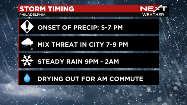
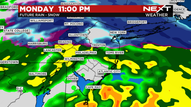
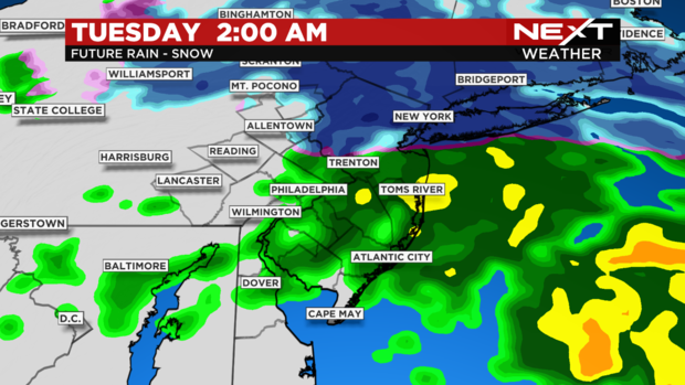
This is mainly a nighttime storm with the heaviest precipitation between 7 p.m. and 3 a.m.
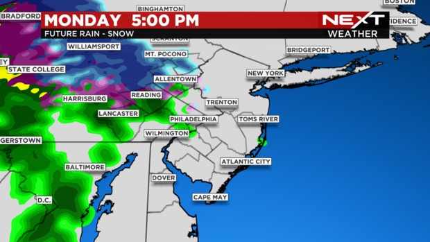
However, we expect the onset of precipitation as early as 5 p.m. in our western zones and between 5 and 7 p .m. in the city.
Precipitation type
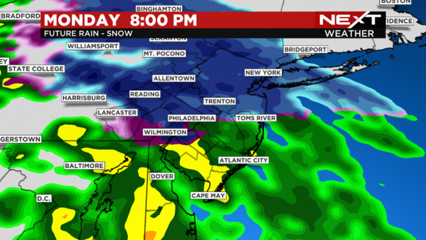
The trickiest part of this forecast is determining what falls where. Delaware and most of South Jersey will see only rain from this event, and the Poconos will see mainly snow.
Areas in between will see varying amounts of mixing, which will determine impacts and snowfall totals.
In the city of Philadelphia, expect a brief period of a wintry mix between 7 p.m. and 9 p.m. This slushy mix of snow, sleet and rain could lead to slushy coatings of less than an inch near I-95 before a changeover to plain rain after 9 p.m.
Proceeding north and west, parts of Montgomery, Chester and Bucks Counties could see a slushy inch or two before the changeover.
In the Lehigh Valley and extreme Upper Bucks County, the amount of rain mixing in may be limited, leading to higher snow totals. However, sleet may mix in with the snow leading to reduced totals, and some of the initial snow will melt on contact.
The good news is that the freezing rain/ice potential will be limited with this storm and there's not much wind, so we aren't expecting dangerous icing or power outages for most of the region.
Snow amounts
Here are the expected snow amounts for the area.
Along and near I-95: Less than an inch
Nearby northwest suburbs: Up to 1 inch
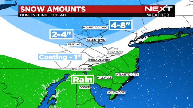
Upper northwest suburbs: 1 to 2 inches
Lehigh Valley, Upper Bucks: 2 to 4 inches
Poconos: 4 to 8 inches
Impacts
The biggest impacts will be felt in the Lehigh Valley and Poconos, where sleet and snow will lead to slippery road conditions and reduced visibility. This may linger into early Tuesday morning and impact the commute so leave plenty of extra time.
Near Philadelphia, slick conditions are possible late this evening before heavy rain will lead to slow travel and ponding on the roads overnight.
The rain should be gone by the morning commute with just a leftover shower.
Alerts
Here are the current winter weather advisories and warnings for the area.
Winter Weather Advisory
Upper Bucks and Lehigh Counties 5 p.m. Monday until 5 a.m. Tuesday
Northampton and Carbon Counties: 5 p.m. Monday until 10 a.m. Tuesday
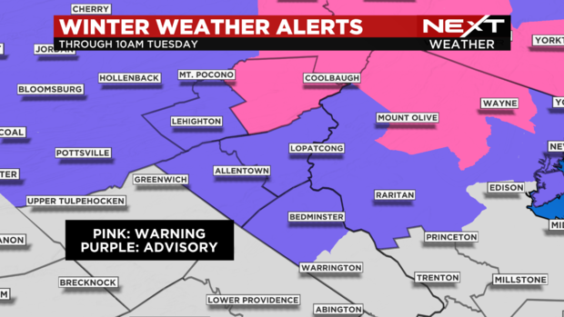
Winter Storm Warning
Monroe County 5 p.m. Monday until 1 p.m. Tuesday